
Projects
 Ajax, BC
Willow Copper-Molybdenum Porphyry
The Yerington district occurs within the former site of a Jurassic-aged subduction-related magmatic arc that marks what was once the western margin of North America. The subduction led to the creation of a large quartz monzonite batholith (dated at 169 Ma) that was emplaced into the arc, and the batholith is directly overlain by a 2-3 km series of cogenetic volcanic flows and interbedded volcaniclastics. The batholith intruded a 3 km sequence of volcanics and sediments.
The batholith was in turn intruded by later granites, with the porphyry copper deposits associated with granite porphyry dyke swarms emanating from this later intrusion. The porphyry deposits are found both along the contact with the batholith, and above within the overlying volcanic rocks. The hydrothermal activity that formed the copper deposits altered a large volume of the surrounding rock above the batholith.
Later faulting formed the basin and range topography characteristic of the area today, causing all rocks to be tilted 60-90° to the west, including the porphyry copper deposits. The net effect in the Yerington district is an exposed cross section through a porphyry district, with the roots in the east and the tops to the west.
Abacus initiated work on the Willow project in April of 2017, to follow up on some initial soil geochemistry and IP geophysics undertaken by Almadex. The Company completed compilation of historic data, detailed geological mapping, soil geochemistry, magnetic and IP geophysical surveys and relogging and sampling of historic skeleton core.
The geological mapping delineated altered rocks covering at least 16 km², over much of the Willow and all of the Nev-Lorraine property. More intense alteration occurs in two, east-west, funnel shaped zones with increasing sericitic, silicic and advanced argillic alteration towards the west or northwest. The northern system covers an area of approximately 1.5 km north-south by 2.0 km northwest-southeast, while the southern zone is 2.5 km north-south by 2.5-3.0 km east-west.
The soil survey outlined broad, strong copper and molybdenum anomalies over the eastern part of the southern alteration zone, with several smaller anomalies to the west. The northern alteration zone contained much weaker soil anomalies.
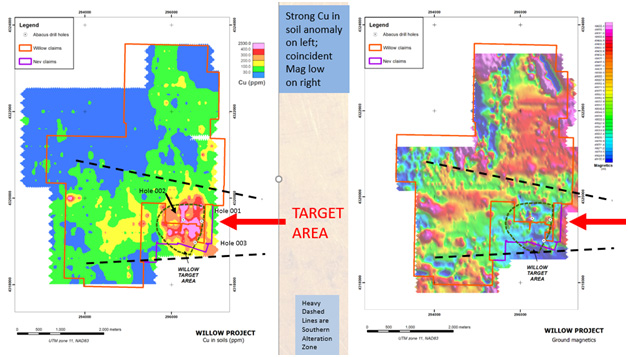
As work progressed, it became evident that the southern alteration zone was larger, with much stronger Cu-Mo soil geochemistry and that it contained a higher proportion of granite porphyry dyke swarms and frequent quartz veining, all of which increase in intensity to the east. Along with ground geophysics and other work described below, a 2.0 km by 2.2 km portion of this southern alteration zone has become the Company's "Target Zone".
Geophysical work entailed ground magnetics and IP. The Target Zone is marked by a magnetic high on the east side, flanked by a very broad magnetic low to the west. The high is thought to be truncated by the Range Front fault to the east, and the low is interpreted to represent strongly hydrothermally altered rocks. A prominent IP anomaly straddles the Willow/Nev-Lorraine property boundary within the broad magnetic low and is thought to represent sulphide mineralization.
The new target was further enhanced by analyzing rock and soil samples collected in 2017 with a spectrometer, which detects any hydrothermal minerals present. The results were then compared with a published 2015 model of hydrothermal alteration and geochemical dispersion around porphyry copper deposits, that was in large part based on studying the adjacent Ann Mason deposit. The model predicts that outward from a porphyry copper deposit, successive alteration halos of Cu, Mo, W, Sn and Se will be developed. The Willow and Nev-Lorraine properties contains this exact pattern within the Target Zone, providing a strong validation of the geological and geophysical interpretation.
In 2017 the Company was able to locate, relog and sample skeleton core from shallow 1970's drilling at Willow. The vertical drilling, most of which was several km west of the new Target Zone, intersected a series of flat lying porphyry dykes with anomalous copper values, thought to represent the upper parts of a porphyry system, plus a series of flat, sub-parallel faults. By examining the geology and geochemistry of these drill holes, an estimation of displacement along these flat-lying faults was made. The Company believes that these faults have displaced the original target zone at depth further to the west and closer to surface, within the combined Willow/Nev-Lorraine property, into an area not previously drilled.
In summary, the new Target Zone is defined by coincident geological, geochemical and geophysical signatures typical of a porphyry copper deposit. It is marked by a 2.0 km by 2.2 km zone of intense silicic and advanced argillic alteration, a high proportion of granite porphyry dyke swarms, and frequent quartz veining. It contains a very strong Cu-Mo geochemical anomaly coincident with a broad magnetic low and an IP high. Geochemical modelling indicates that the Target Zone lies in close proximity to a productive porphyry copper center. The Target is analogous to the Ann Mason deposit to the east and the Yerington deposit further east, but it is thought to represent a separate porphyry center.
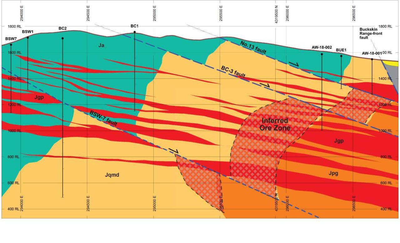
Drilling by the Company in 2018 intersected a key intrusive rock unit on Willow that hosts all known porphyry Cu-Mo deposits at Yerington. This rock unit was not previously known to exist on the Company’s property, and it represents a key new discovery, as there are no known instances in the camp where this rock exists without an associated porphyry deposit. The target is large (approximately 2 km X 2 km) and robust, and it remains essentially untested.
Work completed since the 2018 drilling points to a vector north and west of the area recently drilled. The best potential lies between the #13 and BC-3 faults, where the zone is believes to come closer to surface, although potential also exists below the BC-3 fault. Abacus plans to further test this are by drilling in 2021.
The technical information in this section has been reviewed and approved by Paul G. Anderson, M.Sc. P.Geo., a Qualified Person within the meaning of National Instrument 43-101. It was written based on first hand knowledge of the property, published geological papers and a review of adjacent company's websites. The mineralization and/or resources/reserves of other properties in the district is not necessarily representative of the mineralization hosted on the Company's Willow and Nev-Lorraine Properties.